-
Apr 26, 2021Drone operators challenge surveyors' turf in mapping dispute
Drone operators challenge surveyors' turf in mapping dispute Here's another industry being disrupted by technology: Licensed surveyors are objecting to maps that combine drone images with property lines By BRYAN ANDERSON Associated Press/Report for Amer...

-
Apr 23, 2021China unveils latest drone countermeasures at radar expo
An S-band 3D TWA low-altitude surveillance radar developed by China Electronics Technology Grou...

-
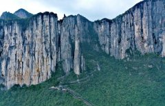
Nov 06, 2020Breathtaking drone view of Enshi Grand Canyon in C China's Hubei
Enshi Grand Canyon is located in Enshi Tujia and Miao Autonomous Prefecture, central China’s Hu...
-
NY Marathon canceled due to COVID-19, but runners to jog on thei Nov 13, 2020

-
International Panda Day marked in Chengdu Nov 13, 2020

-
Women fight for a place at the table as sushi chefs in Japan Nov 13, 2020

-
Ancient Petra a ghost town as pandemic hits Jordan tourism Nov 13, 2020

-
Bartomeu resigns as Barca chief Nov 13, 2020