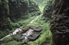
The Kuokesu Grand Canyon in Xinjiang Uyghur Autonomous Region Photo: Pan Ziyi/GT
Northwest China's Xinjiang Uyghur Autonomous Region has risen in popularity recently. Every day, its amazing scenery, diverse culture and delicious food attracts numerous tourists from around the world.
I was one of them.
I landed in Urumqi at midnight, but the staff at the airport were just as enthusiastic as if it were the middle of the day. A friend of mine had asked me to get her personal stuff back from the airport's warehouse, which she left behind the last time she passed through the airport. Even though the staff had already clocked out from work, they were kind enough to stay and help me find what I was looking for.
This was my first impression of the people of Xinjiang, and it was a great first impression.
The next morning, I headed for Sayram Lake. It is 600 kilometers from Urumqi to the lake, which is located in Bole.
Beautiful blessings
Sayram is a Kazakh word that means "blessing."
Sayram Lake is also called the last drop of the Atlantic tears, because it is the farthest place that the Atlantic's warm and humid air stream reaches.
The lake is crystal clear, just like a tear drop. When the sunlight shines through the clouds, the lake begins to glimmer. When the wind whispers past, it creates ripples on the lake, which give the illusion of standing next to the sea. Walking along the lake shore, you can see mountains in the distance hidden by mist, with sheep and cows scattered at their foot enjoying the grass.
The Xiata Village Cultural Scenic Spot was also on my travel list.
Xiata is the Putonghua (Standard Chinese) pronunciation of the Mongolian word "shat," which means "ladder." Being both a village and a road, the Xiata Village Cultural Scenic Spot crosses the main ridge of the Tianshan Mountains at an altitude of 3,600 meters.
Xiata is also a shortcut through the mountains to southern Xinjiang. In ancient times, it was a very risky road to take along the Silk Road.
Traveling along this route, I was dazzled by the scenery.
A milk-like river flowed through the mountains and cedars were lined up on either side of the road as if they were soldiers guarding it.
As we walked along the river and enjoyed the scenery passing by, we almost completely forgot about the passing of time. We saw several other tourists hiking through the mountains, some were even on horseback.
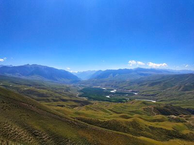
On my third day, I set out to explore the southern Tianshan Mountains. The Kala Jun - Kuksu Scenic Area is located in Tekes county, in the northwestern part of Xinjiang.
Spanning some 1,050 square kilometers in total, the Kala Jun Mountains are 42 kilometers long and 25 kilometers wide and range from 2,000 to 2,800 meters above sea level. The mountains also contain hot springs, waterfalls, beautiful stone forests and wondrous glaciers. The best mountains, meadows and grasslands are in the Yili Kazakh Autonomous Prefecture.
Day three
I arrived in Bagua in Tekes county at 4 pm on the third day. The city's street layout is like a magical maze. Traffic lights are not used here, so be careful when you turn right or left or go straight to get to your destination.
This town reflects the culture of ancient Daoist work the Book of Changes and the mysterious thoughts of the bagua, or the Eight Trigrams.
At the center of the Bagua Culture Square is the Tekes County Museum that explains the history and belief system of the Daoist religion. I was able to see many relics and artifacts dedicated to the concepts of Yin and Yang.
Eight equally spaced main streets go out from the center of the square. The eight main streets are all 1,200 meters long, with a ring every 360-380 meters connecting the eight main streets. There are four ring roads starting from the center and moving out. The first ring has eight sections, the second has 16 sections, the third has 32 sections and the fourth has 64 sections. Using multiples of eight, the streets could extend forever, never stopping, which reflects the meaning of the bagua.
Taking a hot air balloon allows you to fly to heights of more than 2,000 meters above the ground so that you can see the entirety of the city.
The Nalati Prairie is one of the four largest grasslands in the world. The subalpine meadow has been a famous pasture since ancient times. The beautiful grassland scenery combined with the local Kazakh folk customs has made it a famous tourist spot in Xinjiang.
Some Kazakh families live here. Even though they have apartments in Bagua, they chose to spend their summers in the mountains. Each family has a pasture for their horses and sheep and they live in yurts on their allotted pastures.
I was invited to join a Kazakh family, who offered me milk tea and bread. I also visited some Kazakh girls who shared their life stories with me and showed me around the prairie. They all lived in counties nearby, but liked to spend their summer vacations with family members here. Most of them were primary school students while the youngest ones were still in kindergarten.
Road of hope
While the Bayinbulak Prairie is the second largest grassland in China, it is the largest alpine grassland in the country.
The prairie is in an alpine basin surrounded by the snow-capped Tianshan Mountains. It sits at an altitude of 2,500 meters and covers an area of 23,835 square kilometers.
Bayinbulak means "rich spring water" in Mongolian. It is a typical grassland and one of the most important animal husbandry bases in Xinjiang. It's not just a paradise for Greylag geese and swans, but is also an area a lot of protected animals call their home.
The Kaidu River flows through the basin. Also known as the "nine curves and 18 bends," it is a famous tourist spot, especially at sunset. Numerous visitors come here and spend an entire day there just so they can catch a glimpse of it!
I chose to head back to Urumqi by taking the Duoku Road, not just because of the gorgeous scenery along the way but also because of the story of the road.
Duoku Road, which connects Dushanzi in northern Xinjiang to Kuqa in the south, was built between 1974 and 1984. Stretching a total length of 561 kilometers across mountains and valleys, it connects many ethnic minority communities together.
Its construction shortened the travel distance between northern and southern Xinjiang by nearly half, making it a cornerstone project in the history of Chinese highway construction.
It is hard to imagine how difficult it was to build a road across these steep mountains. However, the road gave hope to the people living in the mountains by connecting them with the world so they could enjoy more prosperous lives.
After nine days, I finished my Xinjiang tour. Filled with sweet memories as I returned home, I knew that I would one day go back again to learn more about this wonderful place.
Newspaper headline: Grasslands and mountains